Wednesday, June 16
0800 - Eat breakfast at BnB.
0830 - Work on travelogues.
0920 - Leave BnB, drive north to Red Bay.
1030 - Stop at Red Bay National Historic Site.
1050 - Arrive in Mary's Harbour, get boat to Battle Harbour.
1135 - Arrive at Battle Harbour.
1215 - Lunch at Inn.
1330-1500 - Guided tour of area.
1500 - Catch boat back to Mary's Harbour.
1520 - Saw iceberg fall apart.
1545 - Arrive back at Mary's Harbour, start driving to Cartwright.
1730 - Arrive in Charlottetown, get gas.
1830 - Leave Charlottetown.
2115 - Arrive in Cartwright, have dinner at Mugs Up Restaurant. (2045ADT)
2145ADT - Check-in to BnB. Get flat tire.
2230 - Work on journal and travelogues.
From the Quebec border to Red Bay is about 80km, traversed by the only paved highway in Southern Labrador. Since the highway's construction in the 50s, Red Bay has been the 'end of the road' for the little island of civilization that makes up the communities of the Labrador Straits. Past Red Bay, the rest of Labrador is reached in summer only by air or the seasonal coastal boat which can take a week or two to call on some outports. That is, until now.
In the morning, we left Red Bay to venture out onto the new portion of the Trans-Labrador Highway known as Phase II, completed only the previous fall. The 330km-long gravel extention leads to Lodge Bay, Mary's Harbour and Port Hope Simpson, before making the long journey to Cartwright. Found at the end of Phase II, Cartwright is near the entrance to the huge Hamilton Inlet that divides northern and southern Labrador. The town will now act as the new terminus for the ferry system to even more remote parts of Labrador.
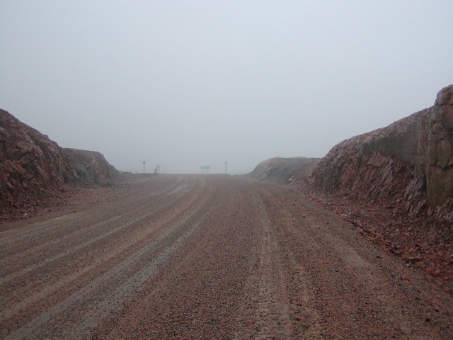
Unlike the trip to Red Bay, the new portions of the Trans-Labrador take us mostly into the unpopulated interior, only popping out at the coast once we near Lodge Bay and Mary's Harbour, some 85km away. Conditions were dry, and the driving fairly easy, given that there was little traffic. In the hour it took us to get to Mary's Harbour, we passed only 2 vehicles going the other way. Along the hilly and windy route we mostly saw forests of thin spruce about 15-20 feet tall. For a few miles, there was an eerie section where all the trees had burned.
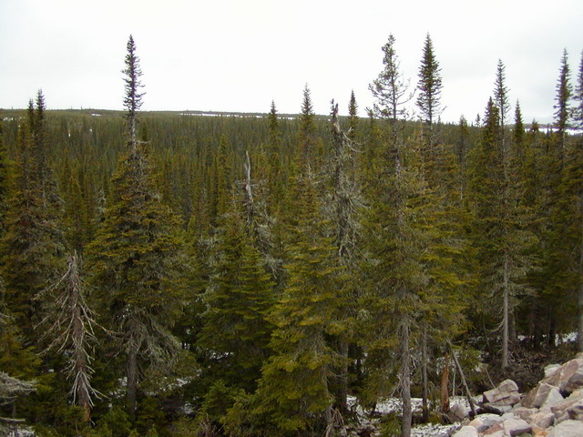
Our first destination was Battle Harbour National Historic District, but getting there requires a 10-mile trip by boat from Mary's Harbour. Since we'd arrived before tourist season, the usual ferry was in for repairs so we took a smaller, faster boat to the island. Accompanying us was another couple, the captain, and his dog. Along the way, we saw many Auks and a couple of icebergs. It was cold on the water and colder still once we reached Battle Harbour.
Battle Harbour was once a central fishing village, the unofficial capital of Labrador in the days of salt cod. Largely abandoned by the 1990s, it became a Historical District because unlike the mainland communities, Battle Harbour kept its roots, continuing to salt cod when modernization swept the industry. In many ways, what's left of the summer fishing post is much as it was 70 or more years ago.
Shortly after arriving, we had lunch at the Inn, followed by a 90-minute guided tour. The Trust has restored about a dozen buildings over the last decade, and continues to work on more of them. While passing through residences, offices, and company storage rooms, it was a struggle to imagine what life may have been like for the fishermen and their families. At the end of the tour, it would have been nice to spend more time exploring the island and various buildings, but the cold, biting wind made it forbidding. As well, the return boat was leaving early, meaning our exploration was at an abrupt end by 3pm.
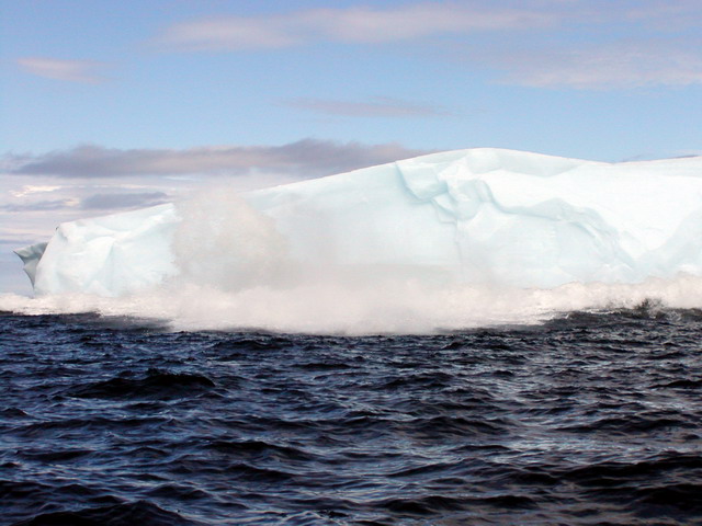
On the trip back to Mary's Harbour, we passed close by an iceberg the size of an apartment building. As we were looking at it, a huge piece of ice fell off into the water. The sound it made was like a building collapsing and it caused a shock wave in the water. The captain of the boat drove us away quickly in case the rest of the iceberg flipped over. In some respects, this was one of the most memorable events of our trip. While it is not rare for an iceberg to break apart, locals can go their whole lives without witnessing it up close as we did within seconds of arrival.
Leaving St. Mary's Harbour, we continued our journey north on the Trans-Labrador. For the next 50km the highway remained fairly close to the coast, and we crossed several spectacular rivers with sweeping vistas. Soon we passed Port Hope Simpson and turning east, took the 30km side route to Charlottetown. This side trip was relatively uneventful, but it did allow us to book our lodging in Cartwright, and fill up with gas - at $1.17 a litre! Charlottetown is practically the last community on the Trans-Labrador until Cartwright, still another 200km away. Having been warned at the gas station that flat tires are quite common, were were a little nervous, since our car does not have a full-size spare.
| Item | Count | So Far |
|---|---|---|
| Moose | 0 |
40 |
| Icebergs | 8 |
25 |
| Ferry Rides | 0 |
4 |
| Auks | 100+ |
100+ |
| Flat Tire | 1 |
1 |
| Northern Lights | 0 |
0 |
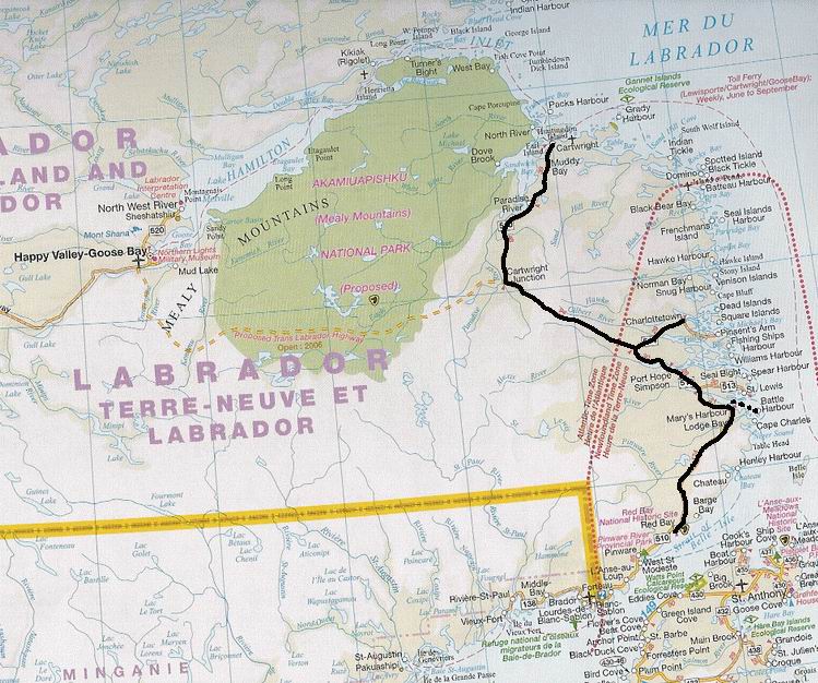
North of the Charlottetown turn-off, the Trans-Labrador becomes truly remote, traversing the Labrador interior. The road becomes slightly more narrow, and the gravel is somewhat coarser. In the 2.5 hour journey, we encountered only 4 vehicles, all going the other way. This was fortuitous considering the flying chunks of gravel are not a welcome sight. Despite our frequent stops for pictures, we saw no one else going our direction.
Evidence of the recent construction is made obvious by the bundles of logs from cleared trees that have yet to be trucked away, plus the numerous graders that we passed. At one point we even came across a mountain of unspread gravel that we just had to photograph. Also, the highway is still under construction in at least one place: one bridge is still under construction, and a diversion via a one-lane Bailey Bridge is still required for now.
Although the views were generally unchanging throughout much of the trip, they were nonetheless fascinating. The highway rolled through majestic hills and valleys seen by few until so recently. Gradually, the highway approaches the foothills of the Mealy Mountains, which are soon to become a new National Park. As it does, one is struck by the vast stretches of stunted spruce and lime-green cariboo moss. Surprisingly, we did not see any animals along the entire route.
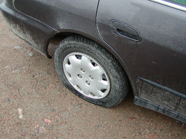
Arriving in Cartwright around 9pm, we soon discovered that along the way, we had crossed back into the Atlantic Time Zone, a half our behind. After dinner at the Mug's Up, the only restaurant in town, we drove to our BnB. Just before turning into the driveway, we ran over an odd-sounding piece of gravel. When we got out of the car, we heard a loud hissing noise coming from the rear passenger tire. While we watched, the tire went flat in a matter of seconds.
Since it was nighttime, there wasn't much we could do about it until the next day. For fun, Ross phoned CAA to see where the closest representitive would be. The dispatcher had a hard time grasping where Cartwright was and didn't realize that we were hundreds of kilometers away from a real garage. It turned out there was a truck back in Charlottetown, but it wasn't worth dragging them out just to put on our spare. We decided to try our luck in town the next morning.
| Reviews | |
|---|---|
| Trans-Labrador Highway | Gravel is a little rough, but overall the new highway is not in bad shape. |
| BnB | The upstairs had just been renovated, and our ensuite room was very comfortable. Breakfast could have been better though ($60) |
| Mug Up Restaurant | There's only two restaurants in Cartwright, and this one's not bad. Considering how remote the town is, prices are fairly reasonable. |
| Battle Harbour | The best part of the trip was unplanned - the iceberg collapse. Touring the island was informative but cold, and way too expensive for the few hours we were permitted (4 hours - $126) |